Passing icebergs?

Aug 22-23

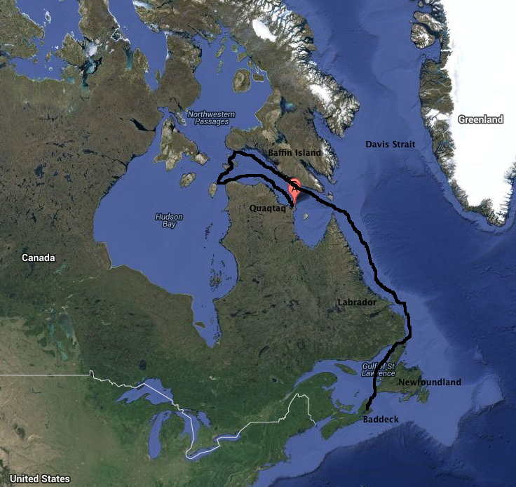
The days, the bays visited, the towering headlands passed, start to mount up. We’re making an overnight passage tonight to gain some distance and deliver Ken to an airport on Monday. The wind is light but favorable, which means that we run the motor and the sails give us another knot or so. We’re farther offshore, picking up another half-knot from the south-running Labrador current, which is also cold — back down to a 42 °F water temperature. It feels like we’ve come along way, but we’re still at 59°N. It’s so simple: each degree has 60 minutes, each minute is one nautical mile (about 1.2 statute miles). (quiz: What’s the earth’s circumference in nautical miles?) That’s always true for latitude, but true for longitude only at the equator. Up here a degree of longitude is much less.

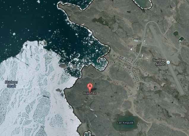
Since the magnetic pole is a good distance from the true North Pole, the compass deviation here is enormous — about 32°. You have to keep doing mental geometry to recall whether to add or subtract from the compass to get true north. Sailing is very geometric — all about angles, distances, bearings, coordinates, vector combinations of boat and current speeds. Quite engaging, if you like that sort of thing. We’re not far enough north, however, for the sun’s behavior to seem strange, as it does above the Arctic Circle. It rises in the east and sets in the west, more or less; sunlight is from 5AM to 9PM; the night is dark.  The general feeling is like home. From a plant or animal’s point of view, of course, the cycle that matters this far north is annual rather than daily. A plant has a couple of months at most when the temperature and light levels allow photosynthesis. The patterns of movement of fish, seals, and bears are are annual not diurnal. I think if I wanted to grasp the arctic ecosystem I would need to go above the Arctic Circle (Disko Bay in Greenland) from the spring to the fall equinox; I’d let the winter go by on its own; I’m not quite that curious.

We keep passing icebergs, some of them quite large. They come from glaciers in northern Greenland (I’ve seen them there!), move north with the West Greenland current, sit around frozen in by sea ice, then move south along the Baffin and Labrador shore, carried by the Larbrador Current. They are carried into bays by tides, grounded on the shallows, become smaller by melting, then move on again. Most are gone by the time they reach Newfoundland — a voyage of two or three years.

On this trip we can see several at any one time. The chance of hitting one is very small, but it is a worry at night. I had the helm from 8 to 11PM, and as the light faded I could see a large berg a bit to starboard a few miles ahead. At 10PM the sun was gone; the moon was not up; where was my berg? Was it still to starboard or was it dead ahead? In the dim night they appear as an amorphous shape on the horizon, a slightly whiter gray than the sea and clouds. You strain to discern a difference that is not imaginary. Finally a believable whitish blob showed up. I was sure when it blocked a lighthouse beacon for a minute (making it several hundred feet wide). I passed it perhaps a quarter-mile away, wondering if I would have seen it in time to avoid it. Probably yes. But what about the ‘small’ ones?..

First polar bear siting!

Aug 20, 21

Each day brings something new. On Aug 20 we made a fair amount of distance, deciding to just sail by Seaplane Cove (from which Alexander Forbes, a wealthy Bostonian with a taste for adventure, spent several summers charting the Torngat Mountains using a seaplane) and on to an uncharted cove a bit farther along. The bottom sloped gently upward terminating in a gravelly river. The shape was classically glacial — a broad parabolic base with sharp mountain faces that had been split away on each side. The scale is astonishing and deceptive, like out west or in the desert. Heights and distances are much greater than they seem. On one side was Razorback Mountain, an aptly named sawtooth 3500 feet high (remember, we’re at sea level a mile or two away); on the other side, an all-white mountain that looked like marble (metamorphosed limestone) but was probably just quartzite (metamorphosed quartz). No google here to learn more.

We were really worried about polar bears, for good reason as it turned out. Each man had a flare gun and we kept close, but we really didn’t know how much security that would provide. We went ashore in the zodiac and Ken stayed behind, fishing from the sailboat, but as we neared shore whole schools of arctic char took off in every direction. It was like minnows in shallow water. So Tim and I walked around a bit (very cautiously) and Finley fetched Ken, who promptly caught our dinner. Char are beautiful fish, closely related to salmon and trout, with a strictly arctic range. They spawn in freshwater gravel beds and lakes like Pacific salmon but don’t die on spawning. Their flesh is deeper orange than any salmon, and they are absolutely delicious.

I waited until the next morning to catch tonight’s dinner, but when Ken and I went out the char were gone. We motored along shore — nothing. As we reached another stream there were a few birds in the water and a seal. Watching the birds splash around (scoters?) I noticed that one of them was larger and whiter than the others. Too big to be a bird. A seal? Too white. Suddenly I registered on the two black eyes and the ears. “Turn around, Ken, it’s a polar bear!” We hastily reversed direction and headed away. But then it stopped swimming in our direction and headed for shore, where it came out and ambled down the shoreline away from us. All was well. Ken was thrilled — his first sighting, in the water, maybe 75 yards away, in a very vulnerable rubber raft.

To round things out, we spotted another bear as we left the cove — this one quite large. We could swing close enough to get some good photos as it ambled along the rocky shoreline. Everyone remarks on the same things: they are so big, so curious, so mysterious, so majestic; their effortless muscular gait is something to behold. Not cute in this their home setting.

We covered another 35 miles to a new fjord with an abandoned Moravian settlement (Ramah). The valley was broad, gently sloping, and very green, with  actual low shrubs (arctic willow and aspen) and many entering steams. The water temperature reached 50° F at the inner end; it was 42 at sea. “No polar bears here, too warm!”, so then of course we spotted another one. Luckily it was on the far side from where the settlement had been, so we felt somewhat safe going ashore and finding the remnants — turf cellar holes, stone foundations, and yellow bricks — in a flat area right along the shore. The beach was sandy, the rock was soft and shaley, the site faced south, the sun was shining. It felt almost tropical! But this was a nice day in August. Finley and Tim took showers in a 15-foot waterfall; I declined. Instead I went fishing, this time successfully: four char for tomorrow’s dinner. As I cast from the zodiac along the shore, I heard heavy breathing every minute or so as a minke whale cruised by. The others saw her baby as well. Pretty fun!

Prancing caribou

August 18 – 19

We had a nicely matched first pair of days on the Labrador coast: the first, windbound in a small cove just south of Cape Chidley; the second, traveling 50 miles down the coast on a perfect day. On the first day Finley decided that staying put would be more fun than beating our heads against the wind in the fog, and he was right. It was like those rainy days at camp as a child, when you had nothing to do but read, eat, and shoot the breeze. In this case it blew 20 knots or more and we were surrounded by bare rock so the feeling was especially cozy. The cabin has a little oil stove; good thing because the water temperature remains around 38° F.

The second day began cloudless and still. We set out early, making our way past one towering headland after another — mountains beyond mountains, all the way down the coast. The rock here is about 2500 million years old, granitic gneiss that has traveled the globe in that time and survived erosion and subduction to become some of the oldest rock on the planet. It is certainly eroded now — rounded by the Ice Sheets, then cut by valley glaciers so that the common shape a broad round mound half of which has been split away to make a sheer vertical face. These are the Torngat (spirit) Mountains of northern Labrador, as majestic as the Alps or the Sierras in their own special way. Imagine touring Yosemite in a sailboat, where the water level is at 9000 feet so you only see the last 3-4000 feet of mountain, and you’ll have a rough idea. But this is the arctic, so the vegetation is all different. Every surface that isn’t vertical or recently split is covered with moss or lichen, and every crevice and outwash plain is tightly felted with tundra plants. All grays and greens. 5 knots is just the right speed to almost take it in. So uniform, yet so various in shapes and textures that the eye never tires — incidentally while scanning for polar bears. None yet. Just tantalizing white rocks.

Our big project for the day, besides admiring mountains, was to find the site where a German U-boat secretly established an automatic weather station in 1943. We knew the cove, and we found the exact site by matching specific boulders and nearby peaks with a black and white photo in a sailing guide. You’d be as impressed as we were if you saw how endless and similar the landscape is. Of course we posed for photos that matched the guide. Several curious caribou were on hand, making their way effortlessly over this rocky landscape. They prance! When they run, the body floats weightless while the legs staccato the irregular ground with incomprehensible precision.

After anchoring and supper in a bay with a panorama of sharp peaks brushed with light snow from yesterday, a full moon came up over the mountains. Magic! The rest of the week looks to be fair. Coming down the coast in 2006, we saw none of this; all was fog above a few hundred feet.

Underway…

Aug 16 and 17
Up at six and off across Ungava Bay, with a following light west wind. The small rocky cove where we spent the night was so barren but nicely protected. As we left, Finley spotted three brown smudges; when they moved we realized the were musk ox. They’re enormous!

The next 36 hours was great by everyone’s reckoning. We had a smooth overnight passage across the top of Ungava Bay (150 miles), with a following and variable wind that meant equal parts sailing and motoring. We took a slight detour to do a drive-by of a barren island (Akpotak) right in the middle. The northern edge had towering vertical cliffs exposing a clearly sedimentary origin, completely different from where we’d been and where we were going (granite and gneiss) and they stood proudly facing the ocean like the white cliffs of Dover.  As we approached, the density of murres increased dramatically until we were surrounded by virtual clouds of birds flying and swimming all around the boat. There are bird cliffs on the island but we didn’t have time to seek them out. Thick-billed murres were described variously the crew as flying penguins or flying footballs: wide in the middle, pointed at each end, with short wings that are used for both flying and swimming, which they seemed equally likely to do when the boat approached. To be more exact, they didn’t seem to be able to make up their mind; they flapped their way across the water, bouncing from wave to wave on splayed webbed feet, then suddenly giving up and diving out of sight.

Saturday morning brought sunrise over the northern tip of Labrador. Instead of going around it, we chose to go through it by a renowned shortcut — a passage called McClelan Strait. which is simply a narrow cut right through the mountains from Ungava Bay to the Atlantic. It’s about six miles long and enclosed by sharply sloping rock cliffs rounded by the last glacier, as improbable as the Panama Canal but natural.  Since Ungava Bay and Atlantic side tides are out of sync, enormous currents race through the strait most of the time. We headed for the opening at the supposed right time and found standing waves made by currents running against us. It was as if someone had opened the floodgates on a dam. So we killed some time and ran through when the current was more favorable. It was miraculously sunny and clear. The cliffs, a lively mixture of metamorphic rock types, woven over with lichens and mosses, were almost hypnotic in their variety-in-sameness. No trees —  nothing in the way of a direct experience of endless bedrock.  It’s a special, dramatic passage; we were all speechless with wonder for the better part of two hours.

Now we’re anchored in a bay on the Atlantic side. I tried my plankton net and microscope, finding modest numbers of copepods and small comb jellies. All this in water that’s at 38° F. Tomorrow we’ll go looking for the remains of a secret German weather station that a U-boat secretly established during WWII. They thought no one would find it up here. They were almost right.

Boarding Elskov

Aug. 15
Near Quaqtaq,
I had the morning to kill so I took a walking tour of Kuujjuaq and the river’s edge. We’re 30 km from Ungava Bay but the river here is truly vast — perhaps a mile across. I think it’s shallow. The edges are very sandy — broad sand beaches that show evidence of great changes in water level.  Certainly no harbor here. Could it be tidal? I saw rapids below the town, but the tidal range here is enormous. There were two oil barges permanently beached perhaps ten feet above the water level — they appeared to be pumpers not carriers. There was a ‘hippie’ (?) settlement of traditional tents. A woman played in the sandy shallows with two small children for at least an hour.

I walked along the beach and up onto the rocky outcroppings that overlook the town and continue forever in every direction. We’re still not above the treeline — tamarack and black spruce reach substantial sizes, and the undergrowth is also large, mostly alder and willow. But the carpeting of the rocks is tundra-like, compact and intense. There are quantities of various berries, such as crowberry, blueberry, and cranberry, probably others as well, all edible but perhaps not tasty. It should be quite a bit more arctic in northern Labrador, where the cold current coming down the western side of the Davis Strait chills the coast.

The town itself is unremarkable until you take in the details of daily living. The older buildings are nondescript — simple well-insulated boxes with small windows. They don’t have the style that the Danish brought to Greenland. The newer buildings are more interesting in a modern-architecture sort of way. It’s still well-insulated boxes, mostly with metal siding, but there are pretensions, mainly skewing of the box shapes in strange ways and adding bright colors to give them some interest, if not attractiveness. Everything is on piers, presumably on permafrost.

There are no roads in and out, but the traffic within town is surprisingly incessant. I think people zoom around just to do it.  Pickups and 4WD cars of various kinds, numbers of ATVs used on the roads as cars, which makes sense. There are lots of government vehicles going this way and that; I guess the season for building and public works is very short. I thought the oil delivery trucks were very busy but then I realized they were sewage-pickup trucks roaming the neighborhoods. There are no underground pipes so there are three truck services to every building: water, sewage, and heating oil. It’s not like Greenland, where all the utility lines are above grade and insulated. I wonder which is cheaper to maintain.

I found Tim Donovan at the airport; he spent the night in the Montreal airport and got a morning flight. The flight to Quaqtaq left at 2PM and he was on it but they bumped me to a make-up flight at 5:30 — the extra people from yesterday’s cancelled flight. It was a small plane with two pilots and six passengers. A  cloud cover settled in but they had visibility for a few hundred feet above the ground, so they could land. I was met by the departing three crew members and relieved to see them; the Elskov really was there! And now we’re way north of the treeline. It makes Kuujjuaq seem like the tropics.

We were driven down to the “harbor”: a breakwater-enclosed basin which at low tide is completely empty! The tides are in the order of 25′. It was almost absurd. So Elskov was at anchor off the shore. We hopped into the zodiac, went on board, packed away the zodiac, and headed out to find a lee anchorage for the night, on the advice of the town manager whom Finley had befriended. No waiting around with Finley!

Meeting the ship

August 14
I made it to Kuujjuaq (spelling is correct), though my shipmate Tim Donovan did not. Halifax was fogged in so he’ll be coming tomorrow. It doesn’t matter, since the flight from Kuujjuaq to Quaqtaq was cancelled and I’m stuck here for a day.  So we’re both delayed. And there’s a week-long music festival “Aqpik Jam” in Kuujjuaq so it appeared there were no hotel rooms and nowhere else to stay.

Things are turning out OK though because  I found the last hotel room from a friend of a man who gave me a ride in town (she works at the hotel), and was able to attend the music evening. It was a genuine auditorium with banked seating at the town hall. Quite a scene: four evenings of mostly folk music, a range of stuff for sale in the hall outside (crafts items, pies, jello with whipped cream, a balloon man making animals for kids, still at it when I emerged from the concert four hours later. The hall itself felt like a family event at the high school: little boys racing around chasing each other, lots of parents with babies, older people, endless comings and goings and greetings. I have the feeling most of Kuujjuaq passed in and out.

The music started at 7:30 with a chorus of little girls in the style of traditional dress (white shifts that are longer in front and back), chanting to the accompaniment of two boys with traditional drums. I think the boys were supposed to be together but they were pretty casual. But then it got better. There’s a tradition called throat singing where two women face each other and each does this amazing combination of deep-throated sounds and regular vocal-cord sounds in a repeated pattern of about two seconds. The sounds are extraordinary and unexpected, almost whale-like. The feeling is intense. It turns out to be a competition: the woman who laughs first loses. In this case, the two women leading the group paired up the little girls (maybe age 6 to 11?) and they went at it, though briefly, more as a demonstration than a contest. There were perhaps a dozen pairs, and each girl’s production was distinct. Then the two women went at it for perhaps a minute or two. The mature version was pretty gripping, and that was before I knew it was a contest!

After that is was traditional music with various combinations of instruments. The first singer was unbearable (I had to cover my ears) but it got better after that. Perhaps the best were the accordion players, first an elderly man and then a husband-wife team (French, Inuit). They really got the crowd going, with a dozen or so adults dancing in front of the stage. A couple got a bunch of children going as well. It seems that the accordion and the dancing that goes with it were an introduction brought from Scotland by 19th-century fishermen. It was picked up and adopted as a local form. The rest of the music was songs with a country western feeling, but obviously predating that, all in Inuit.  The crowd seemed to know a lot of the songs. The MC and all of the performers seemed to have a lot to say, but it was all in Inuit so I don’t know the content.  There were perhaps six sentences and a handful of songs in English. No French. A French-Canadian movie-star-handsome guy said hello to the cheering crowd and reported he’d caught his first Altantic salmon today; he’s performing tomorrow. So they got a few stars to come I guess.

One curious thing I should have asked about was that several performing groups came from Greenland. Is the modern music tradition the same?  Are Canadian and Greenlandic Inuit languages the same? They’re the same ethnic origin but with little contact for several hundred years, I think. Greenlandic is written with a Roman alphabet, Canadian Inuit (Inuktitut) with its own symbols.  Another huge question: how are the two different because of their respective colonial experience (Danish vs English/French)? The two places certainly feel and look different. Greenland has true home rule, and Canadian Inuit are working on it. But there are so many complexities to it that I hesitate to say anything.

A quick geopolitical lesson. The northern part of Quebec is now called Nunavit. It has some self government but is decidedly part of Quebec Province. 90% of the population is Inuit and they mostly speak their native tongue but probably many know both French and English.  Kuujjuaq is the most important town. It seems to be growing.  I have the feeling that, as in Greenland and Newfoundland, government services are being concentrated in a few locations and smaller settlements are losing them

The vast archipelago of island north of there is called Nunavuk. It now has its own local government (like a province?). It has an enormous area and a population of about 13,000. The capital is  Iqaluit on Baffin Island.

Glimpse of the upcoming trip…

I’m not on the boat yet, but here’s from the skipper’s log for the last week. Sounds pretty good!

(Monday) Aug 5

We’re anchored far up Edaloh Inlet on the west end of Salisbury Island at the west end of Hudson Strait. We have no chart for this place (It’s almost as if : “no one goes there; why should we provide charts!?”). Our plotters are off by half a mile in longitude. We had thick fog in the approach. A lee shore, two knots of foul current, and twenty five knots over the transom. On the other hand radar is good, and, of all things, the government Sailing Directions are excellent; so we chanced an inside passage of islands off the larger island and never saw less than three hundred feet under the keel. Once inside the fog lifted to reveal a cloudless sky and sparkling solid rock each side of us broken with swaths of green in places and the occasional sandy beach. Edaloh Inlet is a three mile fjord slotted into the rock at the end of this inside passage. Our only companions here are numerous eiders and glaucous gulls along with guillemots and a raven or two. No bears yet, and no walrus, both reportedly numerous here in the past.

To get here, we enjoyed a fifty mile sail southwest from Cape Dorset where we had spent two days and three nights, having arrived ahead of a rainy gale at 23:00 on Friday evening, at which time we were greeted by Jimmy Manning and his family – Jimmy is Jeannie Padluq’s  brother (from Kimmirut – remember?), who took us in tow the next day with a steel grip which we only excaped this morning. The “grip” afforded us fuel, carvings, dinner, showers, a tour of ancient Inuit sites on Mallik Island opposite the community, a new outboard for the dinghy (it was time!), and intense companionship and chaperone-manship. In return, he got the old outboard, got his wi-fi router set up by Paul, got several first editions provided by Peter, and we had the family to dinner aboard ELSKOV last evening. All this was a pittance compared to our windfall at Jimmy’s hand. He even got me three minutes to greet the community on Cape Dorset Radio!

Cape Dorset is well known as an arts center, and tourists are well known buyers of Inuit art. Every person we met had a knapsack full of carvings to sell – some of it exceptional. We did our best to support the community, but there is a limit. The place is thriving, albeit heavily subsidized as a community. People are open, friendly and generous, with apparently a strong positive self-image. And very interested in our boat. The last sailboat in the harbor was fifteen years ago, or so they said.

From here we go the short distance over to neighboring Nottingham Island, thence by week’s end down to the Nunavik shore at Charles Island and Cap de Nouvelle-France. Wildlife remains elusive and illusive, but we are hopeful.

Tuesday (Aug 6)
Crystal clear quiet morning. Warm in the cockpit.

Very nice hike up to the rocky escarpment above the anchorage (Edaloh Inlet) – gravel beach, muskeag drainage leading up to a small lake in the saddle above; then crumbly fragile rock on the ridge overlooking ELSKOV. Combination of pink quartz, pink granite, some iron-rich sedimentary rock — willow, purple saxifrage, arctic wintergreen, cotton grass. Goose droppings, a few bones on the beach, and some bird remains higher up represented our only wildlife sitings.

Later Tuesday (Aug 8):
We are somewhere in the vivinity of Port du Boucherville on the southeast corner of Nottingham Island (“somewhere” because we have no chart, but only the imprecise description in the government’s Sailing Directions). It’s a peaceful evening, and we feel comfortable anchored in 24′ in an open bay with a small and friendly roll.

Wednesday (Aug 7)
Another “Spahklah” here on Nottingham Island. Lovely walk ashore above the broad     basin to the west and south of our anchor spot (this basin is the “proper” anchorage we think, though we’ve not found the “proper” way in). Green mosses and willows in     the muskeag drainages. Black lichen over all the rock – pink granite and gray sandstones. Nice sitz bath in an ideal small tarne. Quiet exept for a few geese and raven calls, and the sound of surf on the outer ledges.

Thursday (Aug 8)
01:00: (We are bound south and east to Charles Island over night) New day beginning on the Hudson Strait. Northern lights over the starboard quarter. A small breeze filling in. All sail set over a smooth sea; engine on low RPM’s.

03:00: Sun coming slowly up lighting up Charles Island.

06:00: Now anchored in Charles Inlet in 50′. Bottom here appears very level coming up most gradually.

12:30: Underway again for Foul Bay, 47 miles further south and east. Walk ashore on both shores of Charles Inlet revealed a remarkable landscape dominated on a macro basis by a “helmet’ of rock, both granitic and sedimentary, stretching as far as the eye could see, but broken on a micro scale by small tarnes incorporating the most lavish growth of algae and plants – some almost irridescently green. On the southern barrier island we came upon a pair of nesting red throated loons, upsetting them only temporarily we hope. Best wildlife of the cruise to date.

20:00: We’ve come to a wide open cove in the south of Foul Bay. Entered over a two fathom bar, the broad basin inside provides 8 fathoms of sticky holding. Caribou are grazing all around in the evening sun. A broad valley opens into the distant south — all quite verdant looking.

Friday (Aug 9)
Another bright clear calm day (four in a row!).

Walk ashore revealed old stone tent rings, tamer than expected caribou, and a larger landscape than can possibly be imagined.

12:30: Underway for Douglas Harbour to see about a waterfall to fill our tanks.

Thus continues our happy lot here in Hudson Strait on August 9th, 2013.

Finley Perry (Skipper of the Elskov)

Welcome to my summer Arctic sailing trip!

Dear Friends,
This is a pre-departure orienting entry to my 2013 journal of a summer Arctic sailing trip, which will stretch from August 14 to September 15 more or less.  My last Arctic trip, aboard the same sailboat (Elskov) was in the summer of 2006. We left from the same harbor — Baddeck, on the Bra-d’Or Lakes in northern Nova Scotia — where Elskov passes the winter. That was a seven-week loop to St. Johns, Newfoundland, up the western coast of Greenland to Disko Bay, then over to Baffin Island and down the coast of Baffin Island and Labrador, down the west coast of Newfoundland, and back to Baddeck. This year Finley Perry, our skipper, decided to go to another region where yachts are exceedingly uncommon — Hudson Bay. Currently he’s up there somewhere in Hudson Bay, having reached Cape Dorset on the south coast of Baffin Island (the northern side of Hudson Strait) about one week ago. I’ll fly to the southern side of Hudson Strait on August 14 and join them for the trip back to Nova Scotia.
I’m assuming you can look things up on maps.google.com. But I’ve included a rough chart of the route to date. In each posting I’ll provide my current latitude and longitude for you to plug into Google maps.

up_to_aug_14-1

Once you are in Google Maps, you can look up Quaqtaq, Quebec, Canada (as shown below).
Quaqtaq from above

That’s our point of rendezvous. I’ll be reporting on what we find as we make our way south, making the transition from high Arctic permafrost, across the treeline, and south to the boreal forests of southern Labrador, Newfoundland, and Nova Scotia. The internet connection is slow and expensive, so I can send text but not photos.  I’ll try to provide vivid reports. Stay tuned!

Here’s a close-up view of the Elskov.

elskov_at_hornbreen-1